Jefferys, Thomas
A Description of the Spanish Islands and Settlements on the Coast of the West Indies, Comp. From Authentic Memoirs, Rev. by Gentlemen Who Have Resided Many Years in the Spanish Settlement; and Illustrated with Thirty-Two Maps and Plans, Chiefly from the Original Drawings Taken from the Spaniards in the Last War, and Engraved by Thomas Jefferys . . . London: T. Jefferys, 1762. 105 pp. This copy is rebound in modern half polished calf skin and lacks the original frontispiece map. This chart is replaced by a map of the West Indies from Adolf Stieler's "Hand-Atlas. Neue Ausg. 1834.".


This important geographical work was compiled by Thomas Jefferys, engraver and geographer to George III. Jefferys published a great many maps and discussions of North America including a map of Florida published in 1763 in William Roberts' An Account of the First Discovery, and Natural History of Florida. This volume is missing its original binding, having been rebound in modern half polished calf skin. The frontispiece plate, entitled "A New Chart of the West Indies, drawn from the best Spanish Maps, and regulated by Astronomical Observations" is missing. At some point another map was inserted in its place. The replacement map is a fold out map of the West Indies, which has been hand colored to code land ownership by Spain, England, France, the Netherlands, Denmark, and Germany. The volume contains thirty-one other maps and plans "from original drawings taken from the Spaniards in the last war and engraved by Thomas Jefferys, Geographer to His Majesty." The pages and maps in the volume are strong, but in a browning condition with fragile, chipping edges. Some environmental and water damage is notable throughout the volume.
Jefferys states in the introduction that his purpose is to fulfill the curiosity of the public about the parts of Spanish America where the British fleets now are located, not knowing where "next the fury of war will fall." He adds, "In the execution of our design, it is intended to confine the pen chiefly to an account of the sea-coasts, harbors, and towns adjacent to them, of the Spanish acquisitions in the West-Indies; beginning from the eastern part of the south coast of the Tierra Firma, thence along the shore to Vera Cruz, round to Florida, and so to the islands of Cuba, &c." Jefferys relates the history of the area, including discoveries by Columbus, Ponce de Leon, Cortez, and others. From these ventures Spain has taken possession of "far the best and the largest portion of America." Spain is in entire control of the trade between Europe and Spanish America at this point and Jefferys proceeds to describe in detail each type of ship used in these ventures, including: "Galleons, Flota, Flotilla, Register-ships, and Guarda-costas (coast guards)." Jefferys next analyzes the mistakes that Spain has made in America and how proper usage of the territory available to them would have made Spain the greatest economic power in Europe. He concludes his introduction with a brief discussion of the various natural resources found in areas of America and the importance of international trade agreements.
The main text of the volume describes and illustrates with maps and plates the settlements on the mainland coast of Spanish America and on the islands of the West Indies. Two pages are dedicated to Florida, providing approximate geographical boundaries, descriptions of the weather, topographical features, plants, and industries.
Florida proper is, at present, that peninsula lying between Georgia and Cape Florida. The air of this region is pure and temperate, and the country in general, healthy. It is more subject to heat than cold, being only a few degrees north of the Tropic of Cancer; but the former is sometimes very great, it is much tempered at times by the sea-breezes.... The many rivers with which Florida is watered, not only abound with fish, but render it inferior to no country, either in pleasantness or fertility. The coast indeed is sandy; but a little further from the sea is soil so good as to yield all sorts of grain.
Maps of St. Augustine and Pensacola are included, with brief descriptions of the towns and their inhabitants. The history of St. Augustine and various attacks on its fort are provided in great detail. On the map of St. Augustine, a former owner of the volume has penciled in annotations to the layout of the town and the walls of the fort.
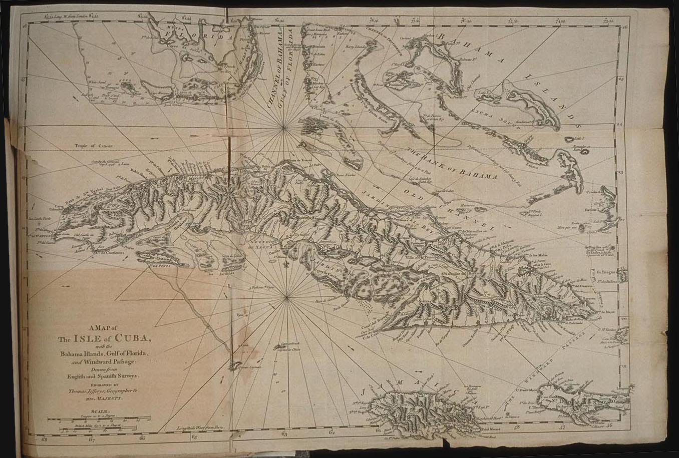
The island of Cuba is described in detail and supplemented with a large fold out map, pictured above. Jefferys describes Cuba as "The Shield of the West-Indies" as it commands the gulf between Mexico, Florida and the Windward Passage. He describes the island as the most temperate and pleasant of all of the Antilles, with many natural resources. Jefferys notes that the greatest problem with Cuba is that it is overgrown with trees. This problem, he adds, is "whatever the Spaniards may pretend, must be chiefly owing to their own laziness; for as they admit the country was well peopled when first discovered, it must necessarily have been less thick with trees." Jefferys tells of the discovery of Cuba by Christopher Columbus and gives a brief discussion of the religions practiced on the island.
Upon the whole, it is a very pleasant, rich, and fertile island; but has at present more churches than farms, more priests than planters, and more lazy bigots than useful labourers: and to this it is owing, that the largest island of the West-Indies, with a luxuriant soil, besides food for its inhabitants, which is easier produced and obtained here than perhaps any other part of the world, does not produce for exportation.... So is the great difference between sloth and industry, tyranny and liberty.