Coxe, Daniel.
A Description of the English Province of Carolana, by the Spaniards Call'd Florida, and by the French, La Louisiane. Viz. I. A Description of the Great and Famous River Meschacebe, or Missisipi [sic]... London: Printed for Edward Symon, against the Royal Exchange in Cornhill, 1727. 122 pp. plus folding map. This volume is bound in antique gilt calf with raised bands. An ornate gilt border on the front and rear covers and marbled endpapers and to the decorative features of this work.
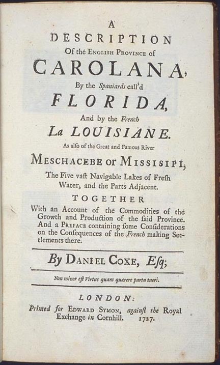
This volume is the fourth edition (reprinting the original edition of 1722) of this important text, one of the first English works to extensively describe the Southeast. Howes and Church assert that this fourth edition was augmented with additions, though the collation remains the same as the earlier editions. They describe the volume as a "bold assertation" of the rights of England to the entire gulf region, including Georgia, Florida, Alabama, Mississippi, and Louisiana. The area of Carolana, which was granted to Coxe's father, Dr. Daniel Coxe II, was the single largest land grant in America by the English Crown to a private individual. This massive region included all of the land from the 31st to the 36th north latitude west to the Pacific Ocean, an area about one-eighth the total land area of the United States and Canada. After several failed attempts to colonize the area, the Coxe family relinquished title to the land in 1769, when Daniel Coxe V surrendered the claim for a crown grant of 100,000 acres in New York.
Coxe, in his preface, explains that the purpose of this book is to provide a description of the colony and the flora and fauna of the area. The text also defends Britain's claim to the province and attempts to present an attractive place for a settlement. Much of the material, gathered from British hunters and explorers, is published here for the first time. Coxe's father, who was the personal physician to Charles II and Queen Anne, participated in many colonial ventures, although he never visited America. The younger Coxe emigrated to America in 1702 and held a number of offices in the government of the Jerseys. He returned to England after several years of land disputes with Governor Robert Hunter.
The goal of both father and son was to establish English colonies in the granted area. All attempts failed. In 1698, the senior Coxe appealed to displaced Protestants in England and Europe to start a colony in the area west of the Apalachicola River. Two ships were sent in the fall of 1698, but were detained by winter weather in Charleston. Captain William Bond sailed one of the ships to the gulf coast and eventually into the Mississippi River, but was dispelled by French forces who claimed ownership of the area. Bond eventually returned to England; the second ship was lost at sea on the return voyage. This volume, published by the younger Coxe in 1722, was intended to revive the Carolana project. Coxe suggested a division at the Mississippi River with the western areas granted to Spain and everything east of the river, except St. Augustine, allocated to England. French representatives in the area would be moved elsewhere.
Though the colonization attempts failed, the efforts of the Coxes' and this published account are historically important. Dr. Coxe was considered one of the first to encourage the emigration to America of imprisoned debtors. His son, frustrated by the lack of cooperation on matters of defense among the British Colonies in America, recommended a colonial plan of union. This draft is often cited as one of the most important features of the treatise because it was one of the earliest printed plans of union for the American colonies. The large folding map, which is often lacking, was drawn up by the Coxe family to further their land claims. The map contains most of the South, including Florida, but also includes northern regions as far as the Great Lakes. It is similar in places to the 1718 map of Delisle and was most likely copied from that map. Between 1722 and 1741, four editions of this work were published. In 1840, after a lapse of a century, Churchill and Harris published another edition. The editors claimed that Carolana could serve as a textbook for the original uncorrupted Indian names for the landforms and communities in the area and for showing the value and resources of the country beyond that of gold and silver. All editions are rare, particularly with the map.
This volume is bound in antique gilt calf with raised bands. An ornate gilt border on the front and rear covers and marbled endpapers add to the decorative features of this work.